|
NWS: Winter Storm WARNING in Effect Until 4 PM
Wednesday
Published: January 18, 2026
at 08:00 a.m.
By: Weather Alert
from National Weather Service
Winter Storm
Warning
URGENT - WINTER
WEATHER MESSAGE
National Weather
Service Buffalo NY
108 AM EST Sun
Jan 18 2026
NYZ006>008-182000-
/O.EXP.KBUF.WW.Y.0004.000000T0000Z-260118T0600Z/
/O.CON.KBUF.WS.W.0002.260118T1200Z-260121T2100Z/
Oswego-Jefferson-Lewis-
Including the
cities of Oswego, Watertown, and Lowville
108 AM EST Sun
Jan 18 2026
...WINTER STORM WARNING REMAINS IN EFFECT FROM 7 AM
THIS MORNING TO 4 PM EST WEDNESDAY...
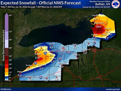 * WHAT...Heavy snow and blowing snow
expected. Total snow accumulations 2 to 3 feet.
Winds gusting as high as 45 mph creating blowing and drifting snow and at
times white out conditions. * WHAT...Heavy snow and blowing snow
expected. Total snow accumulations 2 to 3 feet.
Winds gusting as high as 45 mph creating blowing and drifting snow and at
times white out conditions.
*
WHERE...Greatest snow amounts will be found near Watertown and Fort Drum
areas southward to across the Tug Hill region.
* WHEN...From 7
AM this morning to 4 PM EST Wednesday.
*
IMPACTS...Travel will be very difficult to impossible at times. The
hazardous conditions could impact the Monday through Wednesday commutes.
Gusty winds will down tree branches and cause isolated power outages.
* ADDITIONAL
DETAILS...Expect snowband oscillation. Snowfall
rates up to 4 inches per hour at times for the Tug Hill region Monday night
through Tuesday night. Wind chill values zero to 10 below zero Monday night
through Tuesday night.
PRECAUTIONARY/PREPAREDNESS
ACTIONS...Widespread accumulating snow will create dangerous to impossible
travel
conditions.
Submit snow
reports through our website or social media.
Periods of snow
will result in snow covered roads and limited visibilities. Slow down and
use caution while driving.
|