|
NWS: Winter Storm WARNING Now in Effect Until 7 AM
Friday
Published: January 14, 2026
at 01:15 p.m.
By: Weather Alert
from National Weather Service
Winter Storm
Warning
URGENT - WINTER
WEATHER MESSAGE
National Weather
Service Buffalo NY
1249 PM EST Wed
Jan 14 2026
NYZ007-008-150600-
/O.UPG.KBUF.WW.Y.0003.000000T0000Z-260116T1200Z/
/O.NEW.KBUF.WS.W.0001.260114T1749Z-260116T1200Z/
Jefferson-Lewis-
Including the
cities of Watertown and Lowville
1249 PM EST Wed
Jan 14 2026
...WINTER STORM WARNING IN EFFECT UNTIL 7 AM EST
FRIDAY...
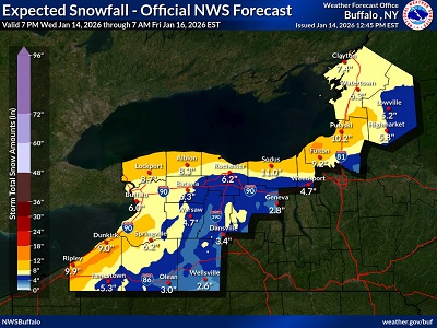 * WHAT...Heavy snow. Total Snow accumulations 5 to 10 inches. Snow will begin on the Tug
Hill Plateau this evening. The greatest accumulations will be on the Tug
Hill Plateau. Wind chills below zero are expected Thursday through Friday
morning. * WHAT...Heavy snow. Total Snow accumulations 5 to 10 inches. Snow will begin on the Tug
Hill Plateau this evening. The greatest accumulations will be on the Tug
Hill Plateau. Wind chills below zero are expected Thursday through Friday
morning.
*
WHERE...Jefferson and Lewis Counties.
* WHEN...Until 7
AM EST Friday.
*
IMPACTS...Travel will be difficult. The hazardous conditions will impact
the Wednesday evening and Thursday morning commutes.
PRECAUTIONARY/PREPAREDNESS
ACTIONS...
Widespread
accumulating snow will create dangerous travel conditions.
Submit snow
reports through our website or social media.
|