|
NWS: Lake Effect Snow WARNING in Effect Until 7 PM
Thursday
Published: January 27, 2026
at 07:00 a.m.
By: Weather Alert
from National Weather Service
Lake Effect Snow
Warning
URGENT - WINTER
WEATHER MESSAGE
National Weather
Service Buffalo NY
355 AM EST Tue
Jan 27 2026
NYZ007-008-271900-
/O.CON.KBUF.LE.W.0002.260127T1200Z-260130T0000Z/
Jefferson-Lewis-
Including the
cities of Watertown and Lowville
355 AM EST Tue
Jan 27 2026
...LAKE EFFECT SNOW WARNING REMAINS IN EFFECT FROM 7
AM THIS MORNING TO 7 PM EST THURSDAY...
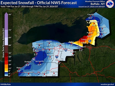 * WHAT...Heavy
lake effect snow that will fall in multiple different rounds as the
band of snow oscillates north and south numerous times over the next few
days. Three day accumulations may reach 8 to 16
inches where the bands persist the longest. * WHAT...Heavy
lake effect snow that will fall in multiple different rounds as the
band of snow oscillates north and south numerous times over the next few
days. Three day accumulations may reach 8 to 16
inches where the bands persist the longest.
*
WHERE...Jefferson and Lewis Counties. The greatest accumulations are
expected across central and southern Jefferson County and far western Lewis
County.
* WHEN...From 7
AM this morning to 7 PM EST Thursday.
*
IMPACTS...Travel will be very difficult at times with snow covered roads
and poor visibility.
* ADDITIONAL
DETAILS...Lake effect snow will oscillate north and south multiple times
today through Thursday. This will bring very changeable conditions,
and also allow for cleanup between rounds of lake effect snow.
PRECAUTIONARY/PREPAREDNESS
ACTIONS...Heavy snow will fall in relatively narrow bands. If traveling, be
prepared for
rapidly changing road conditions and visibilities.
Submit snow
reports through our website or social media.
|