|
NWS: Winter Weather Advisory in Effect 4 PM Today to
10 AM Monday; Winter Storm WARNING in Effect 4 PM Monday to 7 AM Saturday
Published: December 28, 2025
at 09:30 a.m.
By: Weather Alert
from National Weather Service
Winter Weather
Advisory
URGENT - WINTER
WEATHER MESSAGE
National Weather
Service Buffalo NY
222 AM EST Sun
Dec 28 2025
NYZ006>008-281930-
/O.UPG.KBUF.WS.A.0019.251229T2100Z-260101T1200Z/
/O.NEW.KBUF.WS.W.0006.251229T2100Z-260103T1200Z/
/O.CON.KBUF.WW.Y.0042.251228T2100Z-251229T1500Z/
Oswego-Jefferson-Lewis-
Including the
cities of Oswego, Watertown, and Lowville
222 AM EST Sun
Dec 28 2025
...WINTER WEATHER
ADVISORY REMAINS IN EFFECT FROM 4 PM THIS AFTERNOON TO 10 AM EST MONDAY...
...WINTER STORM
WARNING IN EFFECT FROM 4 PM MONDAY TO 7 AM EST SATURDAY...
 * WHAT...For the Winter Weather
Advisory, freezing rain expected. Total ice accumulations around three
tenths of an inch. Winds gusting as high as 45 mph. For the Winter Storm
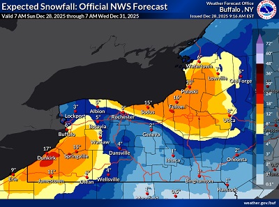
Warning, heavy snow expected. Total snow accumulations
1 to 2 feet. Winds gusting as high as 55 mph creating blowing and drifting
snow along with whiteout conditions at times. * WHAT...For the Winter Weather
Advisory, freezing rain expected. Total ice accumulations around three
tenths of an inch. Winds gusting as high as 45 mph. For the Winter Storm
Warning, heavy snow expected. Total snow accumulations
1 to 2 feet. Winds gusting as high as 55 mph creating blowing and drifting
snow along with whiteout conditions at times.
* WHERE...The
Eastern Lake Ontario Region.
* WHEN...For the
Winter Weather Advisory, from 4 PM this afternoon to 10 AM EST Monday. For
the Winter Storm Warning, from 4 PM Monday to 7 AM EST Saturday.
 * IMPACTS...Slippery conditions
are expected this afternoon and tonight. Some tree damage is likely with
scattered power outages due to the ice. Whiteout conditions are expected starting Monday afternoon and will make travel
treacherous and potentially life-threatening. Travel could be nearly
impossible. The hazardous conditions will impact travel through the week. * IMPACTS...Slippery conditions
are expected this afternoon and tonight. Some tree damage is likely with
scattered power outages due to the ice. Whiteout conditions are expected starting Monday afternoon and will make travel
treacherous and potentially life-threatening. Travel could be nearly
impossible. The hazardous conditions will impact travel through the week.
* ADDITIONAL
DETAILS...Lake effect snow is expected oscillate several times downwind of
Lake Ontario this week. Forecast snowfall amounts could be much higher
where lake bands persist during this long duration event. The strongest
winds will be Monday and Monday night.
PRECAUTIONARY/PREPAREDNESS
ACTIONS...Widespread accumulating snow will create dangerous travel
conditions.
Submit snow
reports through our website or social media.
Periods of snow,
sleet or freezing rain will result in slippery roads and limited
visibilities. Slow down and use caution while driving.
Submit snow and
ice reports through our website or social media.
|