|
NWS: Winter Storm WARNING in Effect 4 AM Wednesday
Through 1 PM Thursday
Published: December 09, 2025
at 01:30 p.m.
By: Weather Alert
from the National Weather Service
Winter Storm
Warning
URGENT - WINTER
WEATHER MESSAGE
National Weather
Service Buffalo NY
119 PM EST Tue
Dec 9 2025
NYZ006>008-100700-
/O.UPG.KBUF.WS.A.0014.251210T0900Z-251211T1200Z/
/O.NEW.KBUF.WS.W.0004.251210T0900Z-251211T1800Z/
Oswego-Jefferson-Lewis-
Including the
cities of Oswego, Watertown, and Lowville
119 PM EST Tue
Dec 9 2025
...WINTER STORM WARNING IN EFFECT FROM 4 AM WEDNESDAY
TO 1 PM EST THURSDAY...
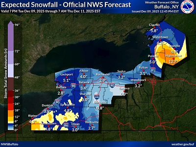 * WHAT...Heavy snow expected.
Total snow accumulations 8 to 15 inches across the higher terrain of the
Tug Hill Plateau and western foothills of the Adirondacks, with 3 to 6
inches in the surrounding lower elevations.
* WHERE...The
Eastern Lake Ontario Region. The greatest accumulations will be across the
higher terrain of the Tug Hill
Plateau and western Adirondacks.
* WHEN...From 4
AM Wednesday to 1 PM EST Thursday.
*
IMPACTS...Travel will be very difficult with snow covered roads and poor
visibility. The hazardous conditions will impact the Wednesday
morning and evening commutes.
PRECAUTIONARY/PREPAREDNESS
ACTIONS...Widespread accumulating snow will create dangerous travel
conditions.
Submit snow
reports through our website or social media.
|