|
NWS: Lake Effect Snow WARNING Issued for 1 AM
Thursday Through 1 AM Saturday
Published: November 25, 2025
at 01:15 p.m.
By: Weather Alert
from the National Weather Service
Lake Effect Snow
Warning
URGENT - WINTER
WEATHER MESSAGE
National Weather
Service Buffalo NY
1244 PM EST Tue
Nov 25 2025
NYZ007-008-260645-
/O.UPG.KBUF.WS.A.0012.251127T0600Z-251129T0000Z/
/O.NEW.KBUF.LE.W.0010.251127T0600Z-251129T0600Z/
Jefferson-Lewis-
Including the
cities of Watertown and Lowville
1244 PM EST Tue
Nov 25 2025
...LAKE EFFECT SNOW WARNING IN EFFECT FROM 1 AM
THURSDAY TO 1 AM EST SATURDAY...
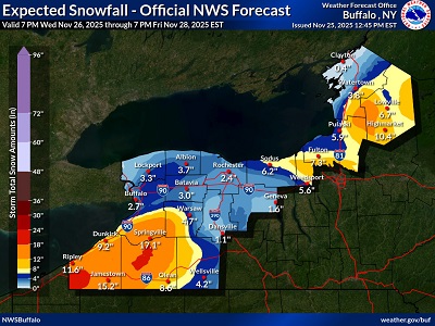 * WHAT...Heavy
lake effect snow expected. Total snow accumulations
6 to 12 inches in the most persistent lake snows, greatest across the Tug
Hill Plateau. Much lower accumulations expected
for lower elevations near Lake Ontario and the Saint Lawrence River. Winds gusting
as high as 50 mph will produce blowing and drifting snow. * WHAT...Heavy
lake effect snow expected. Total snow accumulations
6 to 12 inches in the most persistent lake snows, greatest across the Tug
Hill Plateau. Much lower accumulations expected
for lower elevations near Lake Ontario and the Saint Lawrence River. Winds gusting
as high as 50 mph will produce blowing and drifting snow.
*
WHERE...Jefferson and Lewis Counties.
* WHEN...From 1
AM Thursday to 1 AM EST Saturday.
*
IMPACTS...Travel will be very difficult with snow covered roads and poor
visibility. The hazardous conditions will impact Thanksgiving holiday
travel. Gusty winds will down tree branches and cause isolated power
outages.
PRECAUTIONARY/PREPAREDNESS
ACTIONS...Heavy snow will fall in relatively narrow bands. If traveling, be
prepared for rapidly changing road conditions and visibilities.
Submit snow
reports through our website or social media.
|