|
NWS: Winter Storm WARNING in Effect 10 AM Thursday to
10 PM Friday, Followed by Winter Storm Watch for Friday Night Through
Tuesday
Published: December 14, 2022
at 03:45 p.m.
By: Weather Alert from the National Weather Service
Winter Storm
Warning
URGENT - WINTER
WEATHER MESSAGE
National Weather
Service Buffalo NY
333 PM EST Wed
Dec 14 2022
NYZ006>008-150445-
/O.UPG.KBUF.WS.A.0014.221215T1500Z-221217T0300Z/
/O.NEW.KBUF.WS.W.0008.221215T1500Z-221217T0300Z/
/O.NEW.KBUF.WS.A.0015.221217T0600Z-221221T0000Z/
Oswego-Jefferson-Lewis-
Including the
cities of Oswego, Watertown, and Lowville
333 PM EST Wed
Dec 14 2022
...WINTER STORM
WARNING IN EFFECT FROM 10 AM THURSDAY TO 10 PM EST FRIDAY...
...WINTER STORM
WATCH IN EFFECT FROM LATE FRIDAY NIGHT THROUGH TUESDAY EVENING...
* WHAT...For the Winter
Storm Warning, heavy snow expected. Total snow accumulations of 8 to 16
inches, the greatest accumulations across the Tug Hill Plateau and western
Adirondacks. Winds gusting as high as 35 mph. For the Winter Storm Watch,
heavy lake effect snow possible. Total snow accumulations of 9 inches or
more possible in the most persistent lake snows.
* WHERE...The Eastern Lake
Ontario Region.
* WHEN...For the Winter
Storm Warning, from 10 AM Thursday to 10 PM EST Friday. For the Winter
Storm Watch, from late Friday night through Tuesday evening.
* IMPACTS...Travel could be
very difficult to impossible.
PRECAUTIONARY/PREPAREDNESS
ACTIONS...
Widespread
accumulating snow will create dangerous travel conditions.
Submit snow
reports through our website or social media.
Narrow bands of
heavy snow could impact portions of the region. Localized travel problems
will be possible this weekend and early next week.
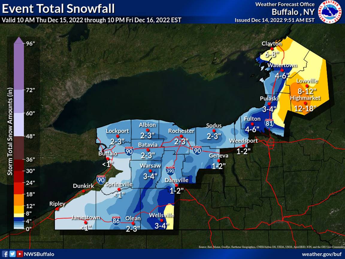
EVENT TOTAL SNOW PROJECTION FOR WINTER STORM WARNING
(Through 10 PM Friday)
|